 Trump has begun another trade war. Here's a timeline of how we got here
 Canada's leader laments lost friendship with US in town that sheltered stranded Americans after 9/11
 Chinese EV giant BYD's fourth-quarter profit leaps 73%
 You're an American in another land? Prepare to talk about the why and how of Trump 2.0
 Chalk talk: Star power, top teams and No. 5 seeds headline the women's March Madness Sweet 16
 Purdue returns to Sweet 16 with 76-62 win over McNeese in March Madness

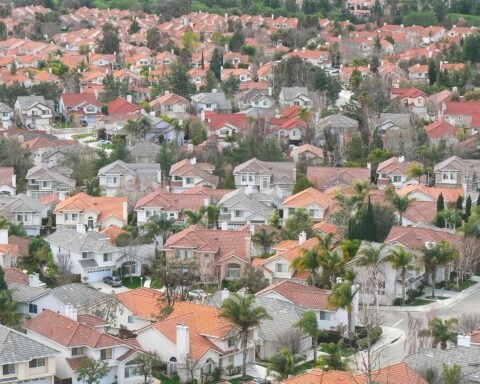
A new map of hazard severity zones established by the California Department of Forestry and Fire Protection greatly expands the areas labeled as being at “very high” risk of fire. Owners of homes within these zones will be required to establish fire mitigation measures on their property.
The last map was issued in 2011. In the years since then, the danger posed by large fires in California has mounted rapidly.
All four of the most destructive fires in California history — The Camp Fire in 2018, Tubbs Fire in 2017, and the Palisades and Eaton Fires this year — have occurred since the last fire danger map was created. The interval has seen a total of seven out of the state’s ten most destructive blazes.
As such, Cal Fire said its maps required revision. “The hazard maps are being updated to more accurately reflect the zones in California that are susceptible to wildfire,” the agency said in an FAQ document. “The hazard mapping process will incorporate new science in local climate data and improved fire assessment modeling in determining hazard ratings.”
The map is intended only to indicate the direct danger posed by wildland fires, which includes airborne sparks that can ignite buildings some distance away from burning vegetation. Cal Fire does not model the impact that burning houses would have on their neighbors. As such, some areas of Altadena – which were affected by the Eaton Fire – are not labeled as high risk on the map.
The largest expansion of the danger zone is in Chino Hills and the surrounding area. The Laguna Hills in Orange County also have significant new risk indicated. Areas near Mission Viejo had their rating downgraded or withdrawn altogether.
In the Hollywood Hills, the very high risk area now extends below Sunset Boulevard in certain places. The “moderate” danger zone now reaches Santa Monica Boulevard in parts of West Hollywood.
In a press release, Cal Fire said risk zones are not meant to impact insurance rates. “Insurance companies must provide discounts for wildfire safety actions such as community mitigation and home-hardening, which CAL FIRE’s maps do not assess. In addition, insurance companies are already using risk analysis tools and models that go beyond CAL FIRE’s proposed maps in determining what properties they will underwrite.”
Property owners within very high risk zones are required to comply with fire mitigation regulations, which limit the height of grass and other vegetation surrounding buildings and fire hazards.