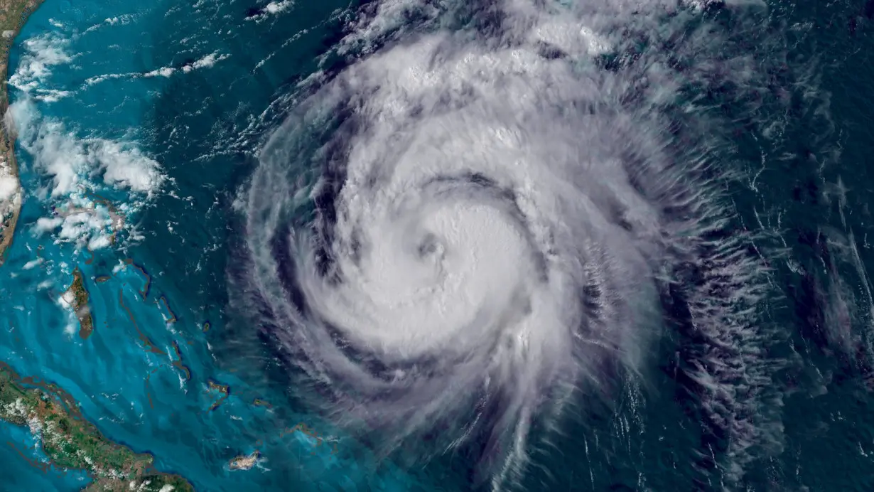
(CNN) — It’s early September – what should be the busiest stretch of hurricane season. Forecasters predicted this one was going to be bad: storm after storm, the most bullish forecasts on record.
Instead, the Atlantic Ocean is enveloped in a rare and strange calm that has flummoxed forecasters and reset their expectations. And the whole thing could be a glimpse at what’s to come as the planet gets hotter.
Despite ideal conditions that fueled pre-season predictions of upwards of 20 named storms, the immediate prospects for one are low, and none have formed in the Atlantic since Ernesto in mid-August – a streak unmatched in 56 years.
“If you had told me a month ago that nothing would (develop) after Ernesto I wouldn’t have believed you,” said Phil Klotzbach, a hurricane expert and research scientist at Colorado State University. “It’s really surprising.”
The strange season has been influenced by extreme atmospheric conditions that are a byproduct of climate change driven by fossil fuel pollution, experts said. And it could also be a “lens” into the more volatile storm behavior of the future, said Matthew Rosencrans, lead hurricane season forecaster with NOAA’s Climate Prediction Center.
Scientists have long said a warming world will ultimately result in fewer but stronger storms something this season has born the fruit of.
Hurricane forecasters, including Klotzbach, were predicting the calendar flip from August to September would revive the season. Many widely used forecast models signaled the same thing. It didn’t pan out.
The conditions ideal for hurricane development – warm ocean water, minimal storm-disrupting upper-level winds and plenty of moist air – are there, but the storms aren’t happening. Lesser-understood atmospheric factors have gotten in the way, Klotzbach said, and they have ties to global warming.
Take that extremely warm ocean water: The Atlantic has been near-record warm since before the season began. It fueled record-breaking Category 5 Hurricane Beryl, a hurricane with such immense strength so early in the season that it was considered a potential harbinger of a busy season to come.
But warm water can’t intensify storms if they never make it there in the first place.
Almost all hurricanes originate from stormy weather coming off the coast of Central Africa. Since about mid-summer, these hurricane seeds have been pushed farther north than usual – even into one of the driest areas on Earth – the Sahara Desert. They have also exited Africa much farther north than normal and have been stunted as a result. Dry, dusty air and cooler ocean temperatures here, off the continent’s northwest coast, have combined to choke off storms.
The northward shift could be tied to the interaction between extremely warm water in the tropical Atlantic and a small patch of abnormally cool water – a burgeoning Atlantic Niña – near the equator, according to Klotzbach and his group at CSU.
The African monsoon is supercharged with a ton of moisture, something that can actually delay tropical storm development, a study published in June in the Journal of Advances in Modeling Earth Systems found. It turns out there’s a Goldilocks zone for hurricanes – dry conditions will starve thunderstorms of the fuel they need, but too much can make them so messy that they can’t organize into a cyclone. The moisture needs to be just right.
“For the first time, we’re seeing that this is actually the case,” said the study’s lead author, Kelly Núñez Ocasio, who is also an associate professor at Texas A&M University. “We’re seeing it right now in the Atlantic hurricane season.”
The scenario could happen more frequently as the world continues to warm because the atmosphere will hold onto more moisture. Further research is needed to definitively determine the change over time, Núñez Ocasio cautioned.
Very warm conditions tied to the climate crisis both at Earth’s surface and higher up in the atmosphere are also limiting the available chaotic energy tropical systems need to form.
Along with warming at the surface, even the highest levels of the troposphere – the layer of Earth where all life and most weather happens – are warming over time, a 2023 study published in the journal Nature found. This trend could potentially keep storminess in the Atlantic much more subdued during the hottest part of the year, similar to what unfolded this year.
The weather weirdness means there are no immediate legitimate storm prospects. If no storms develop by the typical peak of hurricane season on September 10, it would mark a peak-of-season quiet streak unmatched in nearly 100 years, according to hurricane expert Michael Lowry.
Still, experts warn the season isn’t finished and could show signs of life soon.
More than 40% of all tropical activity in a typical season occurs after September 10, so there’s plenty of precedent for storms to reinvigorate the Atlantic in the following months.
Klotzbach believes the season could reawaken by the second half of September, when these limiting factors could start to lessen.
And as the season drags on, the area where storms start to form later in hurricane season creeps closer to the Caribbean and the US coastline, including in the Gulf of Mexico which is record-warm. Plus, La Niña is expected to build throughout the fall and could give a boost to activity in October and November.
Anyone in areas at risk for tropical impacts shouldn’t let their guard down because of the recent lull in activity.
Storms “will come back,” Klotzbach cautioned. “I still don’t see this season ending well.”
The-CNN-Wire
™ & © 2024 Cable News Network, Inc., a Warner Bros. Discovery Company. All rights reserved.

 India's navy launches submarine, warships to guard against China's presence in Indian Ocean
 UK inflation unexpectedly eases in December, which could reduce pressure in bond markets
 Body count from South African mine siege rises to 60
 Question on ASEAN stumped Hegseth at Senate hearing. What is it and why is it important?
 US importers rush in goods from China as Trump tariff threat looms
 Novak Djokovic breaks a tie with Roger Federer for the most Grand Slam matches in tennis history
 China's RedNote: what you need to know about the app TikTok users are flocking to
 British author Neil Gaiman denies ever engaging in non-consensual sex as more accusers come forward
